|
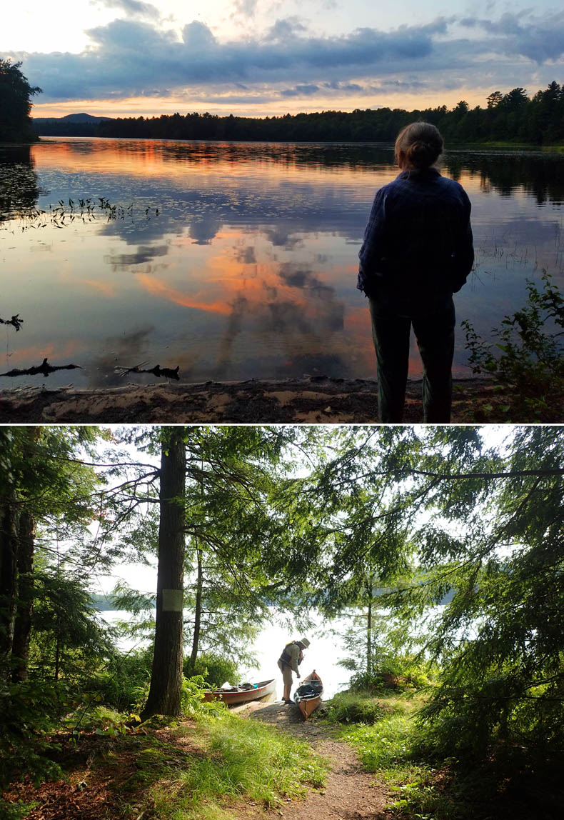
Top: Tammy watches the sunset on our beach.
Bottom: Our launch site at the campsite.
A Perfect Summer Sojourn
Paddling in the Adirondacks
By David Eden Photos by David Eden and Tamsin Venn
August comes around again, and it's time to head north and west through miles of bizarre directions, topped off by an entirely unexpected ferry ride across Lake Champlain (gotta change my Waze!) to meet up with our friends from the Rhode Island Canoe and Kayak Association (RICKA) for their annual trip to the lakes region of the Adirondack (mountains) State Park (ADK). This particular trip was especially welcome, having been deferred for a year because of the pandemic.
Our mounting excitement is somewhat pushed down as we drive for what seems like miles of campers jammed cheek to jowl in the Fish Creek Campground, through which one must travel to reach the adjacent and much less cramped Rollins Pond Campground. The sites here have more room and have trees providing some shielding, totally lacking at Fish Creek.
Our site, A18, is pleasant enough with lake access down a short and steep trail and enough flat space for our REI geriatric special (stoop-in, not crawl-in) tent. We are somewhat bemused by several obvious rain gullies running down the driveway and directly under our tent space. All right, only a quarter-inch deep, but still worrying considering the last weather report I found on my phone before we entered the no-access zone. Warning for heavy rains and thunderstorms.
Day 1 — Sunday, August 8 — Rollins Pond to Whey Pond Loop
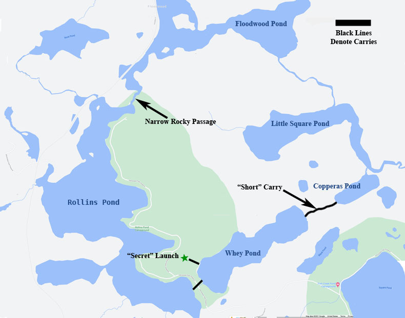
Our Rollins Pond flotilla numbered about a dozen boats, the largest group we would experience this week. (More than 30 people had signed up for the RICKA trip to the ADKs this year, so we were splitting into smaller groups for each day's paddle.) We had been told that the launch was in Whey Pond, which was where we had started this trip in 2015. This put-in was a short, flat carry across the stretch of land between the campground launch ramp on Rollins Pond and Whey. The idea was to drive or paddle to the ramp, carry across to Whey, and head off.
The woman running the canoe, kayak, and paddleboard rental concession at the ramp told us of an alternate launch directly onto Whey, just up dirt road just off that pond. We asked her to tell anyone coming to park with R.I. or Mass plates about the alternative, found the launch and sat on Whey feeling immensely self-satisfied with our foresight. And we sat. "I say, Tammy, they do seem to be taking rather a long time about it," said I as our paddling companions continued not to appear out of the woods at the launch.
At last we realized that something was really wrong and paddled frantically for the Whey launch, schlepped our boats across to the Rollins Pond launch, where the other members of our trip were mostly already in their boats. This year the loop was being made clockwise, not widdershins.
We did this trip in the other direction in 2015 (ACK October, 2015, Vol. 24 #7). Our experience was very similar, although in reverse, so I will let Tammy's description of that trip suffice:
"People paddled from their campsites or drove to the meeting site at the campground launch area and portaged across the street to Whey Pond. A short paddle across Whey brought us to the short portage to Cooperas Pond. Out came
the canoe and kayak wheels again. From Copperas, we paddled the length of Little Square Pond to look for loons that had been sighted there previously, but alas, no loons. A beautiful, narrow, meandering channel about ¾-mile long led us into Floodwood Pond, and we were back into Rollins again via a small
passageway against the current and with quite a few rocks — but navigable. Voila! We're back where we started. That was a good first-day paddle: We left about 10:30, got back at 2-ish. We paddled against the current, but better to do the portage at the start when we were still fresh."
So we ended our paddle near where Tammy and I had sat in unresolved anticipation that morning. We landed and carried over to Rollins with the others, so we could paddle over to our pond-side campsite. I retrieved the car later from the "secret" launch, perhaps a mile trek through the campground.
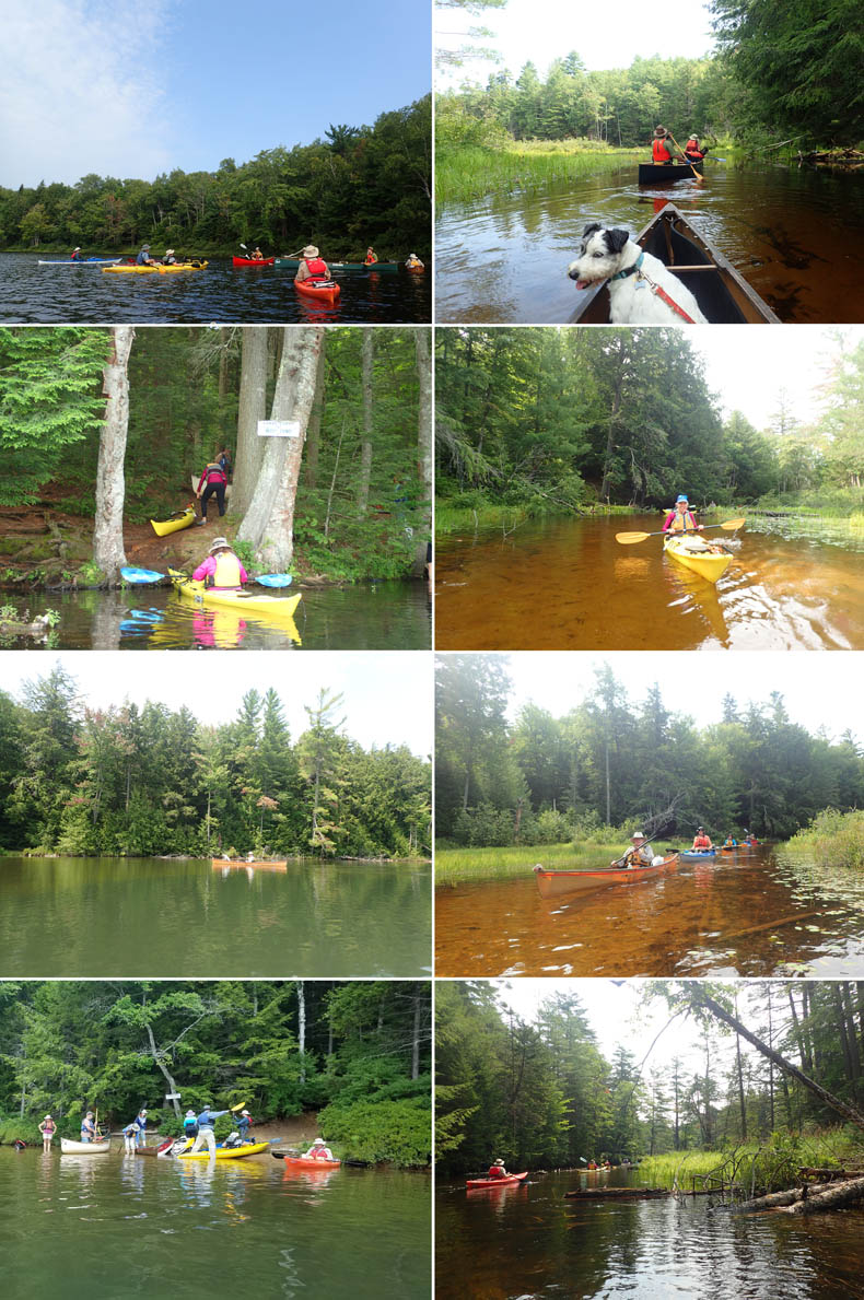
Clockwise from top left: Chuck, In green canoe, gathers the paddlers together before starting out. Milly keeps an eye out for moose.
Next three: The connecting waterways between the ponds are often the most beautiful parts of the trips.
The scrum at the start of the carry into Copperas Pond. David crossing Copperas. The carry from Copperas to Whey Pond.
Distance/Time: 6.67 miles/2 Hours
Leader: Chuck Horbert
Participants: Cindy Horbert, Pat Lardner, Perry Moylan, Gary Powers, Robyn Waterman, Joanne, Jim Crowley, Jim Klowan, Deb Britt, Sue, Frank Cortesa, Janine Cortesa, Tammy and David
Weather: Sunny and really hot
Lunch: Smoked salmon with Boursin, Smoked turkey with cheddar
Dinner: Jambalaya with rice, hot sausage, and tiny shrimp. Forgot the okra.
Day 2 — Monday, August 9 — Upper St. Regis Lake

This day started cold, wet and rainy, and ended in bright sunshine. We headed north on Rt 186 and turned left onto Rt 30 for quite aways until we turned left again on a road with only a tiny sign saying "Upper St. Regis Lake Carry Road." The road ended at a launch next to a private dock area. We started out with six boats, but two of us split off to head for a planned climb up St Regis Mountain, on their way to becoming Saranac Lake 6rs.
The paddle along the west coast of the lake was very nice, with a gentle wind at our backs helping us along. We took the passage between Ward Island and the western shore, through a lovely floating bog, and past a pair of enthusiastically barking golden labs greeting our trio of boat-bound canines. In the narrow passage, the barks echoed back and forth across the water, swelling the cacophony from friendly two to a ravening pack. But their tails were wagging and they didn't try to swim out to attack us.
A major attraction of paddling in this lake is the number of three-to-five bay boat houses in the wonderful Adirondack style of architecture, with natural tree-trunk pillars surmounted by branches angling out to support the roof beams. Occasional glimpses through the trees of the attached great houses provided opportunities for goggling and snarky comments on overly conspicuous consumption. But Oh! what beautiful work. Boathouses crammed with gleaming cedar, hand-fashioned Adirondack guide boats and canoes, as well as antique inboard Chris Craft runabouts, and even a steam-powered launch that looked to be nearly 25 feet long, complete with a striped awning to protect the passengers from the midday sun. This last was at Marjorie Merriweather Post's Adirondack Great House, Camp Topridge,
notable for two (!) railed trolleys to get the inhabitants, guests, and their luggage up and down the steep slope between the shore and the house, as well as the spectacular "Adirondack style" woodwork: baroque detailing using rough pine and cedar boughs.
We continued up the narrow passage of North Bay, ending in yet another bog and the worst landing I have ever seen in this area: very steep side dropping into water one foot deep, but underlain by another foot or so of rotting logs and branches and muck. This just a quick pitstop, and I soon was trying to keep my feet from being trapped in the ooze as I climbed out and in. There was a sign here showing the path to a lean-to that someone had pulled bodily out of the ground and leaned against a tree, pointing nowhere (the sign, not the lean-to).

Clockwise from top left: Chuck and others at the launch. Pat crosses in front of an unnamed islet. We mostly followed the western shore. The group passes one (!) of the Topridge boathouses. Jim contemplates North Bay. Deb leaves North Bay on the return trip.
We returned down North Bay and our gentle zephyr showed its true colors as a feisty breeze from the south that would freshen our faces and push against our paddles all the way back.
Folks were getting peckish, so we poked our nose into Spring Bay and found a pair of floats, one high and new, the other low to the water and very old. This is the the start of the trail up St. Regis Mountain. We found the two kayaks of our mountain-climbing friends there. It was to be our lunch site, but was getting pretty crowded, so I stayed in my boat. Millie on the newer float was delighted at this decision, as it put her nose at the level of my mouth, so she could inspect each bite I took and gaze at me accusingly as it went down my gullet instead of hers. So she got the last mouthful.
After lunch, we decided to do the carry into Bog Pond, a short side trip off the lake. To get there, we paddled back through the Strait of Excited Labs almost to our launch site on the west coast of the lake. This was a much nicer landing and led to a quick up-and-down carry through a deep notch, notable mainly for an eight-foot retaining wall on one side formed of massive cut stones. The trail crossed a dirt driveway and led into a lovely bog rife with pitcher plants, sundews, marsh cranberry, sphagnum moss, and myriads of other bog plants in full summer glory. A short twisting channel led into the pond, which was not even a 100 yards round.
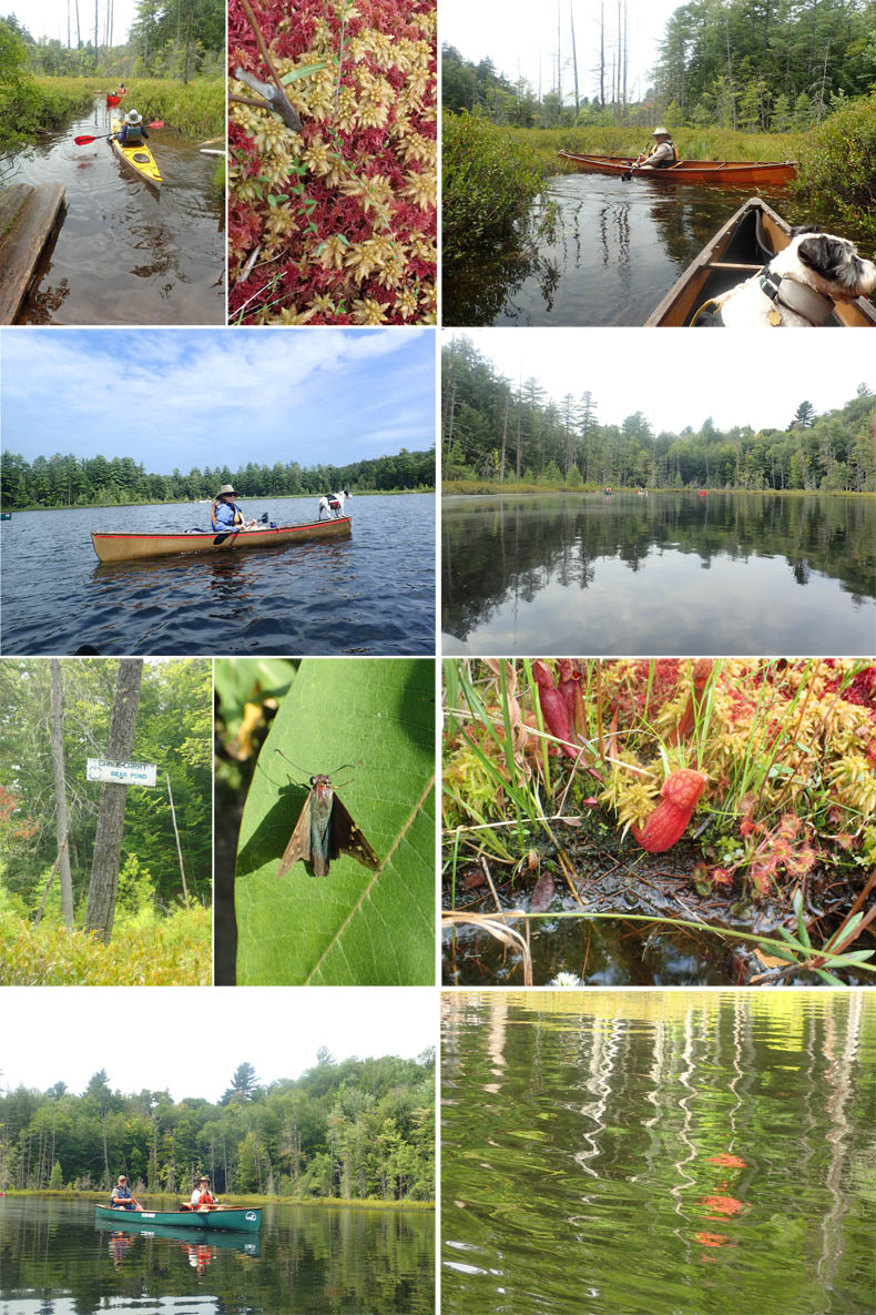
Clockwise from top left: Deb and Pat enter the bog leading into Bog Pond. Multi-colored sphagnum moss forms the basis of the bog "ground." David illustrates that his Hornbeck "canak" is ideal for these narrow bog channels. Bog Pond is largely protected from the winds that can scour the Adirondack lakes and ponds. Pitcher plants and sundews, both carniverous, thrive in the nutrient-poor, highly-acidic bog. A ripple of wind causes Impressionistic reflections of birches, maples, and conifers on the pond. Chuck and temporary partner Jim glide through the still waters. L: The start of the second carry of the Six Carries — Bog to Bear Pond. R: Branded skipper, Hesperia sp? at the Paul Smith's Butterfly House. Milly knows when we're almost back to dry land.
This pond is the start of the historic Seven Carries route (now shortened to six as most paddlers don't go through Green Pond). We returned at last to the launch site, making sure to have our canoes washed with high pressure hot water to be certified clean and free of invasive water plants. We received tokens wired to our boats that would be retrieved by the next washing station, and so avoid inspection again. We found several washing stations at major launch sites.
Washing and inspecting your boat for weeds to avoid transporting invasives from pond to pond is a law in New York State, and students from Paul Smith's College (PSC) ran these as part of their course work in environmental studies. Not as much of a problem for canoes as for motor boats and their trailers, but the students seemed grateful for our patronage. One estimated that only about one percent of the boats he observed using the launch took advantage of the service.
After our paddle, we decided to visit the Paul Smith's College Visitors Interpretive Center (VIC). This was up Rt 30 a couple of miles. It is well worth a visit. We were especially charmed by the butterfly display, a large, netted enclosure filled with flowers and butterflies. We were fortunate enough to view a monarch butterfly caterpillar attach itself and shed its skin, turning into a beautiful green chrysalis with gleaming gold spots in a circle around the top — the "crown" that gave this butterfly its name. Then back to the campground for a swim, a fire, and dinner.
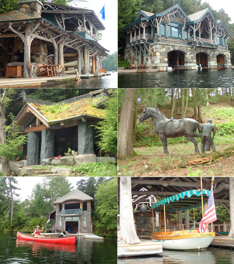
Views of boathouse, statues, and a Norwegian-style summer house on the shore at Topridge, Marjorie Post's Adirondack Great House.
Lower left: Pat poses in front of the boathouse for an Adirondack Not-so-great-but-still-impressive House.
Distance/Time: 7.15 miles/4 hrs
Leader: Chuck Horbert
Participants: Cindy Horbert, Jim, the other Jim, Perry, Sue, Deb Brett, Tammy, David
Weather: Cloudy to sunny, winds mainly from the south and variable 5-8 mph
Animals: Osprey, Loon pairs, one with a baby on its back
Lunch: Smoked salmon with Boursin, Smoked turkey with cheddar
Dinner: Hot dogs roasted over our $5.00-an-armload fire with squashed rolls and mustard and relish packets purloined from various hamburger stands.
Day 3 — Tuesday August 10 — In and Out the Islands of Lower Saranac Lake

A long drive and a shortish paddle. We thought we were going to Middle Saranac Lake, which is fairly open, and were concerned by the evidence of boisterous winds as the trees by the road dipped and swayed disconcertingly. However, we blew past the launch for Middle and kept on to the big parking lot and major launch site for Lower on Second Pond, a widening of this section of the Saranac River. This is also the launch for the trip down the river through the Lower Locks into Oseetah and Kiwassa lakes. (ACK October, 2018 Vol. 27, No. 7 ) Turn right for that trip, but left under the Rt 3 bridge and into First Pond for the way to Lower Saranac.
As it turned out, which lake we were actually on was still confusing some of us, who kept referring to the lake as Middle. But it was truly Lower, and, fortunately, as Tammy and I had done this trip years ago with our kids, we were able to point out the route into the main lake. (It's actually fairly easy, should you go there, as the passage is clearly marked by red and green buoys.)
Lower Saranac is a lake with many motorcraft of various types from canoes with electric motors through family-jammed pontoon boats to speed boats of the most macho varieties, all going very fast. There are also many paddlecraft moving around, so this is not a lake for those seeking wilderness solitude. The scenery is magnificent, however, and this part of the lake is dotted with islands both tiny and largeish, so it is a wonderful paddle nonetheless.
Most of the islands and some sections of shore also have New York State campsites on them. These all require reservations with the exception of the lean-tos, so if you want to camp on one, you had better plan well in advance, as I am sure they go within minutes of the reservation line opening nine months before your desired dates. The reservation site for all the sites, as well as all N.Y. state campgrounds, is Reserve America. This site services campgrounds nationwide, so it's a good one to keep in mind if you plan to camp.
This is officially titled Saranac Lake Islands Campground & Day Use Area and includes 62 sites on Lower and 25 on Middle, for a total of 87 sites. Five have lean-to shelters. Two are wheelchair accessible. All have privies and fire rings. By N.Y.S. law, any firewood you take must have come within a 50-mile radius of the lakes.
The campsites are all numbered with small plaques on a tree near the water, and the best way to tell where you are when visiting this labyrinth of islands is to have a relatively large-scale map of the "campground" handy.
One of the first sights to greet you when you leave the river segment and enter the main lake is the high granite cliff of Bluff Island. At this point, my previous knowledge of the lake was made irrelevant by our turning right and heading north, where we had traveled south before.
My experience of the northern end of Lower Saranac was limited to a motor boat ride with my friend, Steve, from his family's great camp Knollwood Club 20-some years before, so was essentially useless. (The Knollwood Club was founded by Steve's ancestor Louis Marshall, noted N.Y.C. Constitutional lawyer, conservationist, and champion for minority rights, and five friends. Louis was the framer of the "Forever Wild" clause in the N.Y.S. constitution that has preserved the Adirondacks since. It was also the summer paradise and wilderness training ground for Robert "Bob" Marshall, Louis' son and Steve's great uncle; environmentalist; principal founder of the Wilderness Society; mapper of the drainages of the rivers in Alaska's Brooks Range that became included in Gates of the Arctic National Park (a name Bob bestowed on two peaks, Frigid Crags and Boreal Mountain, on either side of the North Fork Koyukuk River; namesake of the Bob Marshall Wilderness Complex; and first person, with brother George and friend and guide Herb Clark, to climb all 46 4000+-foot mountains in the ADKs.)
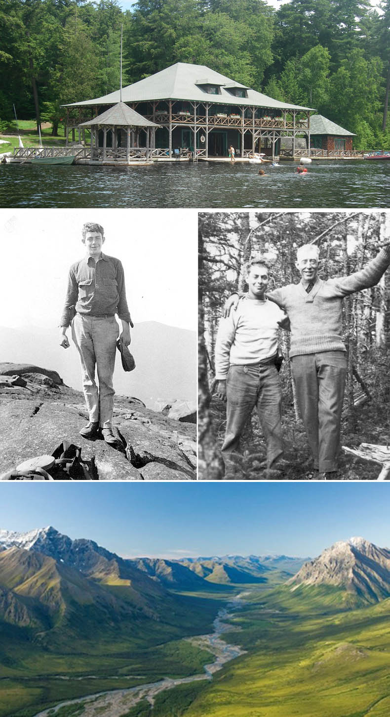
Knollwood boathouse on Shingle Bay. Photos courtesy Stephen Scholle.
L: Bob Marshall on an unnamed Adirondack peak. R: George Marshall and Herb Clark, guide.
Frigid Crags and Boreal Mountain, named "The Gates of the Arctic" by Bob Marshall. Photo NPS Carl Johnson.
I suggested going south, as that was where the wind was coming from, meaning it would be at our backs on the way back, but there are fewer islands in that direction and there is no "in and out and roundabout" paddling which is so much fun.
So in and out and roundabout we went, past Bluff on the left and Little Twins to the right. Passing between Hatcher and Lion, we paddled between Halfway and Green and west towards tiny Otter Island. At this point, we entered an open channel with a long fetch to the southwest. The wind from then south had risen and the waves were beginning to show little whitecaps so we headed back into the islands to find some shelter and a spot for lunch.
This was not all that easy, since most of the good landing spots had campsites attached. We found what seemed to be a good one possibly on Pirate Island, but Frank paddled around a corner and reported the campsite had things on the table, so was presumably occupied. We traveled along the north shore of the island until we found a spot that was not too steep to crawl out and sit on stones and logs. As Tammy discovered when taking Millie for a walk, the campsite was actually empty and we could have sat in comfort around the table. Oh well.

Top row: Tammy on First Pond. David enters the short river segment between First Pond and Saranc Lake.
2nd row: Louise, Gary, and Frank on Saranac Lake. Louise and Frank; the lovely impressionistic effect is an excess of sun block on the lens.
3rd row: Interesting view of the shore. Searching for a lunch landing on Pirate (?) Island.
4th row: Tethered boats on the not very accessible lunch spot. Frank, Gary, Louise, and Tammy against a back drop of some of the High Peaks.
After lunch we headed off south again and came between Partridge and Bluff, although no one recognized it as the big cliff was hidden. I could see the red and green buoys that marked the channel back into First Pond, but was outvoted, so we headed across to Pope Island and entered Pope Bay, which, as it turned out, has no outlets. Tammy and Louise were hanging back next to campsite #53, whose resident was explaining loudly and adamantly that Frank, Jim, and I were heading up the proverbial creek and would never be seen again. A hearty whistle from Louise brought us all back to try again.
Heading north out of Pope Bay, we almost immediately spotted the high cliff on Bluff. "How did we miss seeing THAT?" was the question we could not answer, but directly across from Bluff we found the buoys marking the channel back into First Pond, under the Rt. 3 bridge, and return to the launch site. As usual, Tammy and I find a trail for an after-paddle walk.
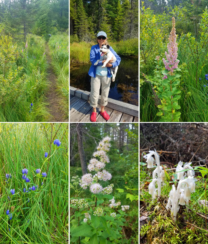
Clockwise from top left: The nice walk we found. Milly, looking particularly moronic, and Tammy crossing a bog. Flower ID?. The ghost plant (non-PC name "Indian Pipe") Monotropa uniflora. Flower ID?. Closed Bottle Gentian (Gentiana andrewsii). If you can identify the question marks, please let us know: Atlantic Coastal Kayaker.
Distance/Time: 6.32 miles/3 hrs 32 min
Leader: Louise Price
Unofficial assistant leaders: Everybody had their opinion. ("Leadership is not a democracy," Louise says.)
Participants: Jim, the other Jim, Frank, Tammy, David
Weather: Sunny and hot, with winds from the south rising to 15-20 mph
Animals: Bald Eagle, deer, several Loon pairs, two Kingfishers, one of which hit the water fishing twice, Osprey diving.
Lunch: Smoked salmon with Boursin, Smoked turkey with cheddar
Dinner: Elbow Macaroni with Lisa's special meatballs and sauce.
Day 4 — Wednesday August 11 — Hoel Sweet it is! Hoel Pond to Turtle to Slang to Long and return
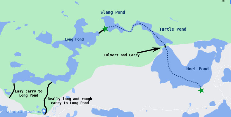
We were hoping, and had been told, that we were starting in Long Pond and going from there to the other three in reverse (Long to Slang to Turtle to Hoel), but Henry decided to start at Hoel and only do three ponds. The other trip would have required a long shuttle, a quarter mile carry into Long, and a relatively rugged carry between Slang and Long.
To access Hoel, we turned off Rt. 30 onto Floodwood Rd., poorly marked with a tiny sign. When Floodwood bore to the left, Hoel Pond Rd. went straight ahead then curved along a golf course fairway, then into the woods to the launch fairly hopping with lots of human powered boats launching and landing. From the parking area to the pond was down a set of very rough steps, but the bottom of the pond was relatively free of muck and branches.
We crossed Hoel Pond, the widest of the three ponds on this trip, to an old railroad bed in the northwest corner of the pond. This bed is very obvious from this side of the carry, and is marked by the four-foot wide circular culvert. The carry over the railroad bed is extremely steep and the footing treacherous on sliding bluestone. Fortunately, there were a few inches of water racing down the culvert, making it an easy job to slide our boats through to Frank, waiting at the other end.
Watch a video: Sending the boats through the culvert under the old railroad tracks into Turtle Pond.
The culvert led us into Turtle Pond (no turtles were seen, unfortunately). This was a short paddle to a lovely marshy pass through into Slang. There was one shallow gravelly sluice where we had to get out and walk our boats for a few feet, but the bottom was clean and firm and the water deliciously cool, so no one was complaining.
We crossed Slang and ate lunch at the start of the carry over to Long Pond. The landing was extremely mucky. Tammy, Millie, and I walked over the carry to dip our hands in Long Pond.
As we got back into our boats, disaster struck! Henry was climbing into his We-Noh-Nah Kevlar canoe when one foot stuck in the muck, dumping him and Nell in the pond. It was a baptism in the woods for Nell, who had remarked on the hardiness of "you outdoors people" earlier. Well, now she is one of us.
The trip back to the launch site had its own little adventures. First of all, there was some difficulty in finding the culvert back to Hoel, as the bank of the railroad bed and the culvert were disguised by a thick growth of vegetation. Once we found it, there was some discussion as to how to get our boats back through. I just got some help lifting my canak over the three-foot lip of the culvert and, trailing a long line made from my towline and Louise's painter, pushed it through the culvert up to Hoel, crouching down through the low culvert, no algae so it was not slippery.
I passed the line back down, and Henry added a float to the end, and the whole operation went smoothly.
After a hot and sunny afternoon, dark clouds and thunder seemed fast approaching, darkening the day and making us all nervous, so we raced back across Hoel. The launch site was not visible until we got fairly close to the opposite shore, so there was a bit of poking our noses into false coves as the sky grew more and more threatening. At last we were on the right track, and slid into the access just in time for the storm ... to slide by.
Tammy and I decided to find the carry to Long Pond, so we turned off Hoel Pond Road onto Floodwood, which changed to dirt about two miles in. It seemed like a very long drive, until we came upon a large clearing with a St. Regis Outfitters outpost and a big sign showing the carry to Long Pond. As it turns out (after we walked a long way down that carry) the carry we were seeking was a farther mile up the road. We went to that parking area and found the wide, smooth carry we had been looking for, at about 500 meters. (Carry distances on the local maps are all in meters.) We headed up the trail, had a refreshing swim au natural, although Milly kept her coat on, the modest little beast, and that was the end of this day's adventure.
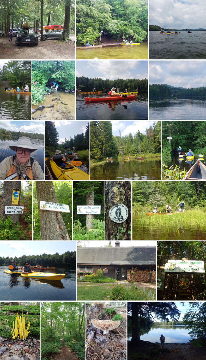
Top row: The parking lot. Leaving from the Hoel launch. Heading out across Hoel into wind and lowering clouds.
2nd row: We reach the conduit under the old railray embankment. Frank stands inTurtle Pond and catches a boat. Jim on the Turtle Pond crossing. Tammy cuts a swathe of sliver in the dark reflections on the pond.
3rd row: David takes a selfie on Turtle. The shallow passage from Turtle into Slang. On Slang Pond. The landing at the carry into Long Pond and lunch!
4th row: Pics 1 to 4: Most of the popular carries in the ADKs are marked, although some of them are painted brown and are nearly impossible to see from any distance. They often admonish the traveller to follow the markers. The actual markers are very rare, and never seem to be found at trail junctions. The highlit oval of bark reminded us of a woods troll sneering at the carriers dilemma. Pic 5: Prelude to disaster — Henry, about to sit in his canoe, will find his foot stuck in the mud as he tries to sit and is about to be flung into the drink.
5th row: Frank and Janine heading back on Hoel, with David and Millie in the background. St Regis Canoe Outfitters' outpost on Floodwood Road, directly opposite the misleadingly official carry sign; in fact, the easier carry is a mile farther on, while this one is narrow, very steep in places, and quite lo-o-ong.
6th row: While an awful carry, this trail made a very pleasant walk. The heavy rains this season have brought out some beautiful fungus growths. The distal end of Long Pond provided a secluded spot for a delightful swim at the end of our hike.
Distance: Around five miles
Leader: Henry Dziadosz
Participants: Nell, Jim, Frank, Janine, Louise, Tammy, David
Animals: Loon pair with brown plumaged young'un
Weather: Breezy changing to hot hot hot, just racing in ahead of a thunderstorm
Dinner: Tuscan mac and cheese with spinach and chicken, crudities with hummus
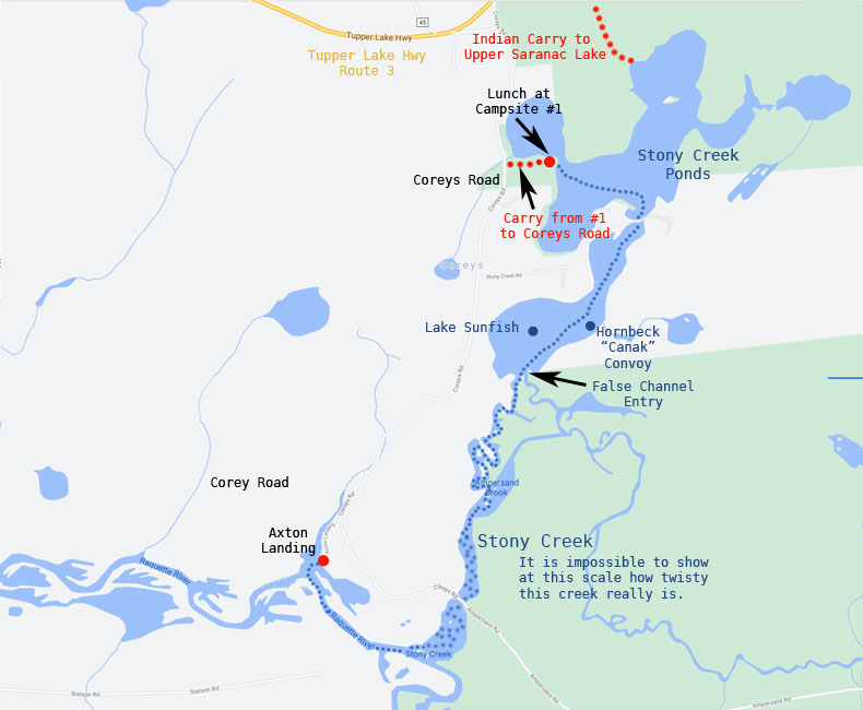
Day 5 — Thursday August 12 — Axton Landing to Stoney Creek Ponds and return
We have already covered this trip in ACK, October 2015 Vol 24 #7 and paddled it a few times. We had planned to go off on our own, but wanted to stick with our fun group of people.
Louise was rousted out to lead it after the original leader bowed out and so, barely wakened, without breakfast, and thoroughly understandably just a wee bit grumpy, led the convoy off along Rt. 30 to 3 to Coreys Road on the right.
It is true that Axton Landing is one of the nicest launch sites around here, with good access down to the water, and a nice sand beach to launch from. Mosquitoes were remarkably bad, though. We scrummed around and set off upstream on the Raquette ("Racket") River.
A few hundred yards leads to a very obvious white sign leading, again upstream, onto Stoney Creek. (I have also seen this spelled "Stony Creek," even on official sites, but I will go with the sign on its outlet.) There On a milkweed leaf on the bank here we saw a monarch butterfly caterpillar, seemingly preparing to hang from its butt and turn into a chrysalis. We were excited to think we would see the pale green, jewel-like chrysalis with its "crown" of brilliant gold spots around the top on our return downstream. (We didn't. It was still chomping on leaves, the greedy thing.)
Many of the streams in this area are mazes of meanders and oxbows, with large marshy areas along the banks (this is an old river system), and Stoney Creek is no exception. Where it got its sobriquet, "Stoney," is beyond me, as the bottom is almost entirely large masses of long strands of river reeds waving in the current. Aside from the occasional lovely wildflower, this section of the trip is one theme of back-and-forth until you just wish it would make up its bloody mind.
Finally you reach Stoney Creek Ponds through a large bed of lily pads that hides the return channel. There are houses here and often the locals toodle around on sunfishes or canoes or even small motorboats. Here we saw the "lake sunfish," as well as three women in Hornbeck canaks like Tammy's. "Hornbecks forever," I called as I raised my fist. "What say?" one called back. She thought I was telling her to look out for the rock.)
Crossing the first pond, we passed under a bridge into the second pond. These do not have separate names on the map.
There are six primitive campsites around this second pond, as well as two carries, one from a campsite back to Coreys Road, and one farther up the pond, a very long and steep carry, still labeled "Indian Carry," that leads to Upper Saranac Lake.
We lunched at the campsite at the end of the Coreys Road carry. "Ten minutes to eat!" came the call, as the wind was rising and there were thunderstorms predicted for two in the afternoon. Several of the participants were very worried about the possibility of being caught in the storm. So we gobbled our food and headed back the way we had come.
There was some confusion as to the way to go when we reached the point that Stoney Creek entered the ponds. There was a nice, clear, obvious channel on the left, and a mass of lily pads with no obvious channel on the right. Unfortunately, the water reeds showed the clear channel current was going the wrong way, and after some discussion about whether it is possible for a stream to flow in two directions, we got it straightened out and headed properly downstream.
Then it was a meander back to Axton landing. I got some very nice photos of flowers and a beautiful mushroom, probably deadly poison. The storm expressed itself in the usual Adirondacks way, threatening and then giving just a light drizzle. (It could just as easily been a deluge, so the worriers weren't worried for no reason.) Landing was fairly difficult, as a camp trip for teen boys took up most of the beach as they consumed a very leisurely lunch.

Top row: The launch at Axton Landing. Two ways to go.
Row 2: 1-3 — Traveling upstream on the Raquette River. 4 — Jim turns in on Stoney Creek. 5 — Monarch butterfly caterpillar on milkweed.
Row 3: 1 — Cardinal flower (Lobelia cardinalis). 2 — Louise follows the sign to Stoney Creek Ponds. 3-4 — Up the creek with plenty of paddles.
Row 4: 1 — Negotiating yet another meander. 2 — Out onto the first pond, at last. 3 — Landing at the campsite off of Coreys Road for lunch. Paddled for miles and ended nearly back where we started. 4 — Tammy, Frank, and Jim chow down in the ten-minute lunch window.
Row 5: 1 — Returning under the Stoney Creek Road bridge. 2 — David and Milly enjoy some quiet water. 3 — A camp for teen boys takes up mosty of Axton Landing for a lunch break.
Distance: 6.6 miles
Leader: Louise shanghaied
Participants: Jim, another Jim, Frank, Robyn, Gary, Joanne, Tammy, David
Animals: Loons, bald eagle, monarch butterfly caterpillar, lake sunfish
Weather: Partly sunny with threatened afternoon storm, rising winds which never really caused a problem.
Lunch: Super chunky, organic, no emulsifier PB and raspberry jam
Dinner: Spaghetti again.
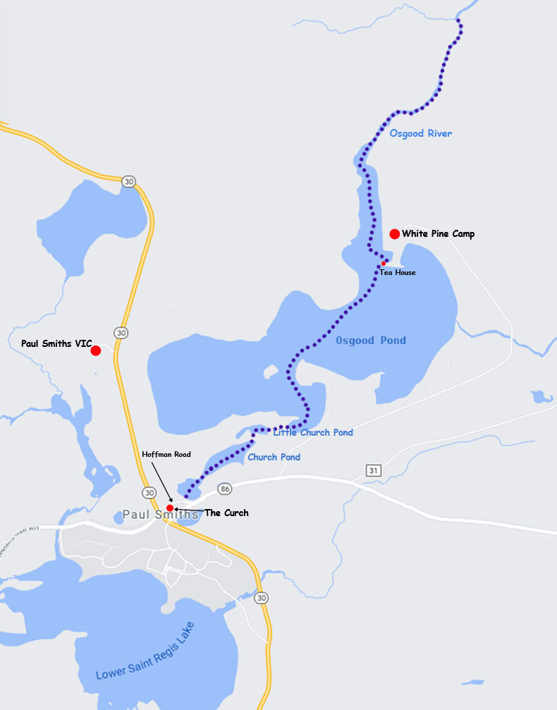
Day 6 — Friday August 13 — Church Pond through Little Church to Osgood Pond and Osgood River and return
Osgood Pond was the one trip this week that Tammy and I hadn't done and we were quite excited to try it out. No one else seemed interested (Henry had led a trip there earlier in the week that some of the other RICKA members had been on), so we decided to go it by ourselves.
Looking at the inset on the Adirondacks Paddlers Map - St Regis Canoe Wilderness, we thought the way to the launch pretty straightforward. Just head north on Rt. 30 to Paul Smiths College then look for Hoffman Road on the right. Bad choice. After wandering around a bit and going way too far north on Rt. 30, we stopped at a large dirt pull-out and asked the hot-dog vendor plying his trade there where Hoffman Road was.
"Never heard of it."
"What about Church Pond?"
"Dunno about that, but there's the church right there," he replied, pointing to a steeple of wood covered in peeling white paint.
So we drove up the dirt road, past the dilapidated and abandoned old church and through the woods until we saw a pond to our left and Rt. 86. roaring with traffic, dead ahead. Also on Rt. 86 was a big sign advertising the launch site.
The unmarked dirt road was, of course, the Hoffman Road we had been seeking, and the pond was Church. Room for maybe six cars to park at this end of the road, and a relatively steep but grassy walk down to the pond edge.
We had chosen to launch at Church Pond, rather than at the main launch into Osgood, as we really wanted to paddle the intimate water trail leading from Church through Little Church and then out onto Osgood.
Unlike many pond-to-pond trips in the Adirondacks, this one did not require carries or marshy flows between each body of water. This would be unique in our experience, as the ponds were connected by two hand-dug canals, apparently made in the 19th century to allow people from Osgood Pond to go to the church.

Clockwise from top left: The very obvious sign on Rt 86. Our boats ready to launch onto Church Pond. Tammy heads out. The Church Pond narrows. L & R: The hand-dug canals form some of the most intimate and evocative paddling we have seen. On the open water; don't ask me why this isn't considered a lake. The boathouse at Northwoods.
The paddle through the relatively tiny ponds was charming and lovely. There are walking trails around with a couple of rustic benches on shore and a couple of bridges over the canals, but for us, on the way out, the experience was one of solitude and quiet, broken only by birdsong and the sound of wind in the trees, for even the roar of cars diminished to a murmur as Rt. 86 pulled away from the ponds. Here the roaring wind that would face us on the main pond was tamed to a gentle zephyr.
On our map, the Church Pond shoreline resembles the silhouette of a whale swimming to the northeast. The shoreline was typically Adirondackical, but much more intimate than the usual experience of seeing at least one shore in the distance. The first canal is situated right where the blowhole would be. It was easy to find on the water and was a cool break from the brilliant sun in the open. The water was very shallow, sometimes less than six inches, but plenty for our canaks.
Little Church's outline looks like a beaver's silhouette, and the canal enters right on its hind foot. This pond is similar to Church, but even more so, being much shallower and having several downed trees that need to be navigated around to reach the canal into Osgood. This was a sheer delight, a long, deeply shaded and cool paddle through the boreal pine forest so typical of the region. The scents of pine and moldering detritus made a delicious perfume as we paddled the shallow water. Like the other canal, this was crossed by a bridge connecting the network of hiking trails around Paul Smiths. We had no trouble getting through, but I did read one account which described some difficulty passing under the bridges. I don't know what they were paddling, because we had plenty of overhead clearance.
The canal ended in a little cove on Osgood's southern shore, about 100 yards west of the main canoe launch on Osgood. This was where Henry's trip had put in.
The cove is bounded to the east and north by peninsula tipped by Northgate Lodge, an Adirondack Great Camp built in the 1920s a in the State and National Registers of Historic Places. We paddle past its impressive boathouse. To the west on our left is a small island whose name, if any, I have not been able to discover.
We are heading across the pond in a northeasterly direction towards a T-shaped peninsula forming the right side of the mouth of the Osgood River. This is the site of White Pine Camp, yet another Great Camp. One of the main architects of the camp was the controversial Addison Mizner, better known for his influence on the architectural styles of South Florida. The complex was offered to Calvin Coolidge and his wife as the Summer White House of 1926.
We stopped here at the tip of the T-shaped peninsula to examine the tea house and Japanese bridge, famous landmarks of this region. Fortunately, there was no one about to question our presence. The bridge especially was showing its age, but the area, connected by a long footbridge to the boathouse downhill from the main camp, was still charming. One the pond side of the point is a small swimming area marked off by floats and kept free of detritus. Tammy slipped into the deliciously cool water for a swim.
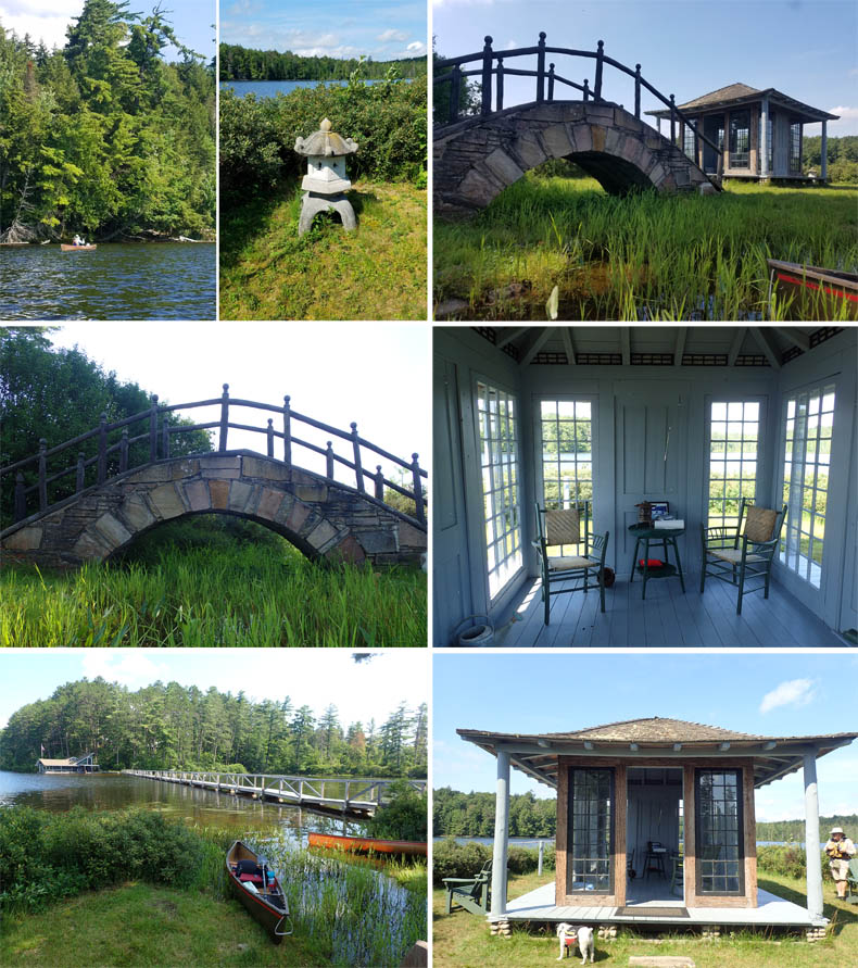
Clockwise from top left: Along the northwest coast to the inlet of the Osgood River and White Pine Camp. The stone lantern at the tea house. The Japanese-style bridge and tea house. Interior of the tea house. Entrance to the tea house; the swimming area is through the bushes on the left and there is an emergency phone in the building. The long bridge from the tea house point to the boathouse. Another view of the Japanese bridge, notable for very Adirondack features such as the rough pine log railing and field stone construction.
Back in our boats, we headed across the bay, which is really the inlet of the Osgood River. At the teahouse, the Osgood is fairly wide, and the wind effect is as powerful as that on the open pond, especially in the afternoon. The river flow is almost indiscernible as it leaves the pond Heading for Meacham Lake. Water lilies and pickerel weed choked large sections of the river and were in full beautiful bloom as we wandered through and around them. The river narrows quickly, maintaining a meandering course, as it takes on the characteristics of a typical Adirondack deep stream, with close banks clad with leatherleaf and conifer-clad shores. It is three miles to an old rock dam at the end of navigation. There are several beaver dams that are reported as easy to cross, and scattered campsites for resting. We only paddled in about one mile before turning around. (We had to get back to break down camp and start our long haul back to Ipswich.) The river is also one of the best areas in the Adirondacks to spot the American Three-toed Woodpecker, one of the rarest birds in New York State. Alas, we saw no woodpeckers, just our usual Loons and Banded Kingfishers.
We now turned back towards the launch on Church, and found the paddle straight into the wind as difficult as we had expected. As we neared the southern shore, we had a much better sight of Northgate Lodge, and could discern a fairly large family group of canoes and kayaks heading in the same direction. They admitted to be uncertain of the way, saying that they planned to take out on Church Pond. We told them how to go and moved on as they coalesced on the shore.
Fearing to be caught in the scrum of boats that sharing the landing with the family would create, we pushed with a little more speed towards the opening of the canal into Little Church Pond. The return trip was a lovely as the first.
Coming out of the canal into Church, we noticed a couple of round, floating objects out on the pond. At first they seemed like partially deflated soccer balls. But then I noticed some beach chairs and clothing on shore, and realized they were two heads wearing colored bathing caps. They just floated there with their bodies and limbs hidden in the water. Very odd. Perhaps they were skinny dipping and didn't want to be caught out.
At last, we were back on shore and loaded up. Back to camp; two hours to break camp and reload everything; and we were heading out of Rollins Pond Campground at the end of this year's Adirondack adventure.
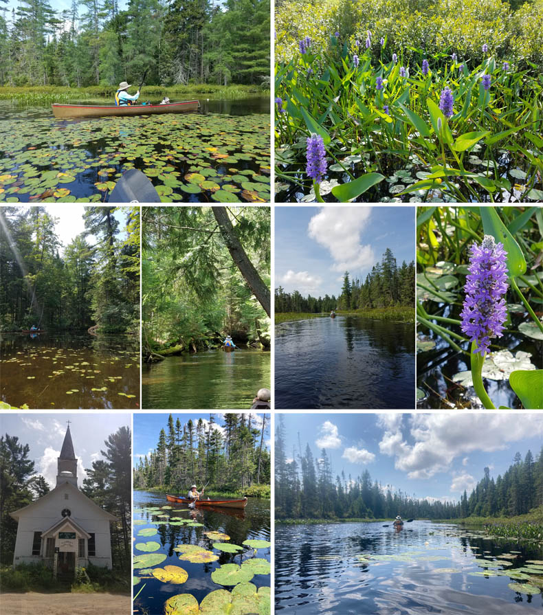
Clockwise from top left: Tammy amongst the lily pads in the Osgood River. The masses of pickerel weed blossoms is a visual delight in quiet, shallow waters in Adirondack ponds. L: The Osgood River narrows rapidly as it very slowly flows towards the forest. Pickerel weed is one of the prettiest wildflowers around. David heads upstream as the channel narrows. R: And he heads downstream after the turn around; not time to dawdle today, alas! L: The deserted and dilapidated, though historically significant Catholic church that was the reason for all the canal building. The entrance to the canal from Osgood to Little Church Pond. Back into the magical canal.
Distance/Time: 5.7 miles/2 hours 25 minutes
Leaders/Participants: Tammy and David
Animals: Common Loons with young, Banded Kingfisher kingfishing, doe and two fawns
Weather: Bright and sunny, strong breeze in our faces on return
Lunch: No salt, super chunky, organic, no emulsifier PB and raspberry jam on whole grain bread thins
Dinner: McDonald's
|